Last edited on .
Published on by Cody Stratton.
The federal lands map:
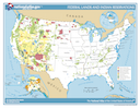
I noticed that there were a lot of complaints lately about the seizure of lands from the federal government, especially in the western US. So I checked out the official goverment map. As can be seen from the map, there certainly is more federal land ownerships on the western half of the continential US. Even if the Bureau of Indian Affairs was taken out of the map, the bias remains. This is a source of ire for many westerners.
The population density map:
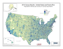
I also found a population density map that seems to be the federal lands map's opposite.
The correlation:
There are numerous habitats across the country. Most of them needed suffient protections. They tends to to be found in rugged areas. Why don't the government preserves all the enviroment that needed preservation? In populated areas, that would be nearly impossible, because a lot of people would mad from losing their home. Imagine evacuating the city of New York just because it sit on top of a delicate ecosystem (I am not sure that the ecosystem is delicate; I am just trying to make a point.). I think the government preserves lands that are not owned yet simply because it is easier to take than privately owned properties and because they believe it will protect the natural organisms (which sometimes don't include humans). Is it unfair because more lands on the west is conserved, or is it fair because the government protects the remaining unowned lands almost evenly and weighted by uniqueness?